
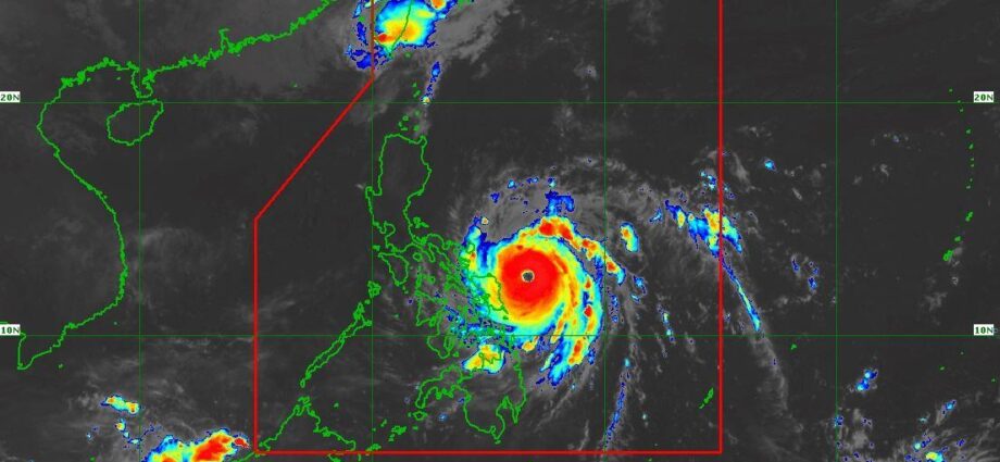
TYPHOON Pepito (international name: Man-Yi) is expected to reach super typhoon strength before making landfall over Catanduanes tonight or early Sunday, November 17. According to the Philippine Atmospheric, Geophysical, and Astronomical Services Administration (PAGASA), Pepito poses a significant threat with its sustained winds and potential for widespread destruction.
In its 8 a.m. bulletin, PAGASA reported that Pepito was located 235 kilometers east of Catarman, Northern Samar, moving northwest at 25 kph. It has maximum sustained winds of 175 kph and gusts reaching 215 kph. The storm is projected to intensify further before landfall.
Landfall Scenarios and Path
PAGASA predicts Pepito will move west-northwestward over the weekend, making landfall in Catanduanes or nearby provinces. Alternative scenarios include potential landfall along the eastern coasts of Camarines Sur, Albay, Sorsogon, or Quezon, extending into Aurora by Sunday afternoon or evening.
After hitting land, Pepito is forecast to traverse Bicol Region, Central Luzon, and nearby provinces, bringing heavy rains, severe winds, and storm surges. The typhoon is expected to weaken slightly while crossing land but will remain dangerous, potentially downgrading to a severe tropical storm once it exits into the West Philippine Sea by Monday morning.
Signal Warnings Raised
PAGASA has raised Tropical Cyclone Wind Signal (TCWS) No. 3 in the following areas:
Luzon: Catanduanes, eastern Albay, eastern Camarines Sur, and eastern Sorsogon.
Visayas: Eastern Northern Samar and northern Eastern Samar.
These areas may experience wind speeds of 89 to 117 kph within 18 hours, posing significant threats to life and property.
Meanwhile, TCWS No. 2 is in effect for regions including the rest of Camarines Sur, Albay, Sorsogon, Camarines Norte, and parts of Quezon, Samar, and Eastern Samar. TCWS No. 1 covers Metro Manila, Central Luzon, and other provinces in Luzon, Visayas, and Mindanao.
Storm Surge and Sea Conditions
PAGASA has issued warnings for life-threatening storm surges, with potential peaks exceeding 3 meters along coastal areas of Eastern Samar, Northern Samar, Bicol Region, Quezon, Cavite, Batangas, Metro Manila, and the Ilocos Region.
The seaboards of Catanduanes, Northern Samar, and Camarines provinces are expected to experience waves of up to 14 meters, rendering sea travel extremely risky for all types of vessels.
Heavy Rains and Precautions
Authorities are warning residents to prepare for torrential rainfall that may cause flooding and landslides, especially in low-lying and mountainous areas. Disaster management offices are on high alert, and evacuations are being implemented in high-risk zones.
PAGASA urges the public to monitor updates and heed local authorities’ advisories for safety. For region-specific warnings, follow updates from PAGASA’s regional services divisions.
Stay safe and vigilant as Typhoon Pepito makes its approach.