
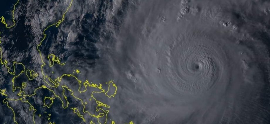
Typhoon “Rolly” has maintained its strength, according to the state weather agency, the Philippine Atmospheric Geophysical, Astronomical Space Administration (Pagasa).
In the last severe weather bulletin, the typhoon was last seen 345 kilometers East Northeast of Virac, Catanduanes around 4:00 p.m, Saturday.
It still has wind speeds of up to 215 kilometers per hour near the center and gusts of up to 265 kilometers per hour.
The storm is moving in the West-Southwest direction at a speed of 25 kilometers per hour.
As a result, Tropical Cyclone Wind Signals (TCWS) are elevated in the following areas:
Signal no. 3:
– Catanduanes; Eastern portion of Camarines Sur (Cabusao, Libmanan, Pasacao, Pamplona, Magarao, Bombon, Calabanga, Canaman, Camaligan, Gainza, Naga City, Milaor, San Fernando, Minalabac, Pili, Ocampo, Baao, Bula, Balatan, Nabua, Bato, Iriga City, Buhi, Sagnay, Tigaon, Goa, Tinambac, Siruma, Lagonoy, San Jose, Garchitorena, Presentacion, Caramoan); Albay
Signal no. 2:
Luzon
– Bulacan; Rizal; Metro Manila; Laguna, Cavite; Batangas; Quezon including the Polillo Islands; Camarines Norte; Rest of Camarines Sur; Sorsogon,
Masbate including the Ticao and Burias Islands; Marinduque; Romblon; Oriental Mindoro and Occidental Mindoro along Lubang Island
Visayas
– Northern Samar; northern portion of Samar (Hinabangan, Paranas, Motiong, Jiabong, Catbalogan City, San Jose de Buan, San Jorge, Tarangnan, Gandara, Santa Margarita, Matuguinao, Calbayog City, Tagapul-An, Almagro, Santo Nino, Pagsanghan); northern portion of Eastern Samar (San Julian, Letters, Taft, Can-Avid, Dolores, Maslog, Oras, San Policarpo, Arteche, Jipapad)
Signal no. 1:
Luzon
– Pampanga; Bataan; Zambales; Tarlac; Nueva Ecija; Aurora; Pangasinan; La Union; Southern portion of Ilocos Sur (Quirino, Gregorio Del Pilar, Salcedo, San Emilio, Candon City, Galimuyod, Santa Lucia, Cervantes, Sigay, Santa Cruz, Suyo, Tagudin, Alilem, Sugpon); Mountain Province; Benguet; Ifugao; Nueva Vizcaya; Quirino; Central and southern portions of Isabela (Mallig, Quirino, Ilagan, Roxas, San Manuel, Burgos, Gamu, Palanan, San Mariano, Benito Soliven, Naguilian, Reina Mercedes, Luna, Aurora, Cabatuan, San Mateo, Cauayan City, Dinapigue, San Guillermo, Echague, San Agustin, Jones, Angadanan, Alicia, San Isidro, Ramon, Santiago City, Cordon); Calamian Islands
Visayas
– Rest of Eastern Samar; Rest of Samar; northern portion of Leyte (Leyte, Tabango, San Isidro, Calubian, Capoocan, Carigara, Tunga, Barugo, San Miguel, Babatngon, Tacloban City); northwestern portion of Aklan (Numancia, Lezo, Makato, Tangalan, Ibajay, Nabas, Malay, Buruanga, Kalibo); northwestern portion of Antique (Libertad, Pandan)
According to Pagasa, the typhoon center is expected to pass through the Catanduanes – mainland Camarines Provinces area, Sunday morning (November 1), while on mainland Quezon on Sunday afternoon.
Violent winds and intense rainfall will be experienced in Catanduanes, Camarines Provinces from Sunday morning to afternoon while in Quezon from afternoon to night.
After passing through the Southern Luzon – Metro Manila area, PAGASA said the mainland Luzon landmass will release the typhoon on Monday morning, November 2.
The typhoon will remain in the ‘typhoon category’ before landfall.
The weather bureau warns that on Saturday, the outer rainbands of “Rolly” will carry light to moderate which is sometimes heavy rains in the Bicol Region and Eastern Visayas.
Starting Sunday morning, expect heavy to intense rains in Metro Manila, Bicol Region, CALABARZON, Aurora, Bulacan, Zambales, Bataan, Marinduque, Romblon, Occidental Mindoro, and Oriental Mindoro.
Moderate to heavy rains are sometimes intense rains in the Cagayan Valley, Cordillera Administrative Region, Ilocos Region, and the rest of Central Luzon, especially in the eastern sections of Northern and Central Luzon.